
Articles
Reading the Landscape: Grim’s Dykes
01 03, 13 Filed in: Countryfile | Reading the Landscape
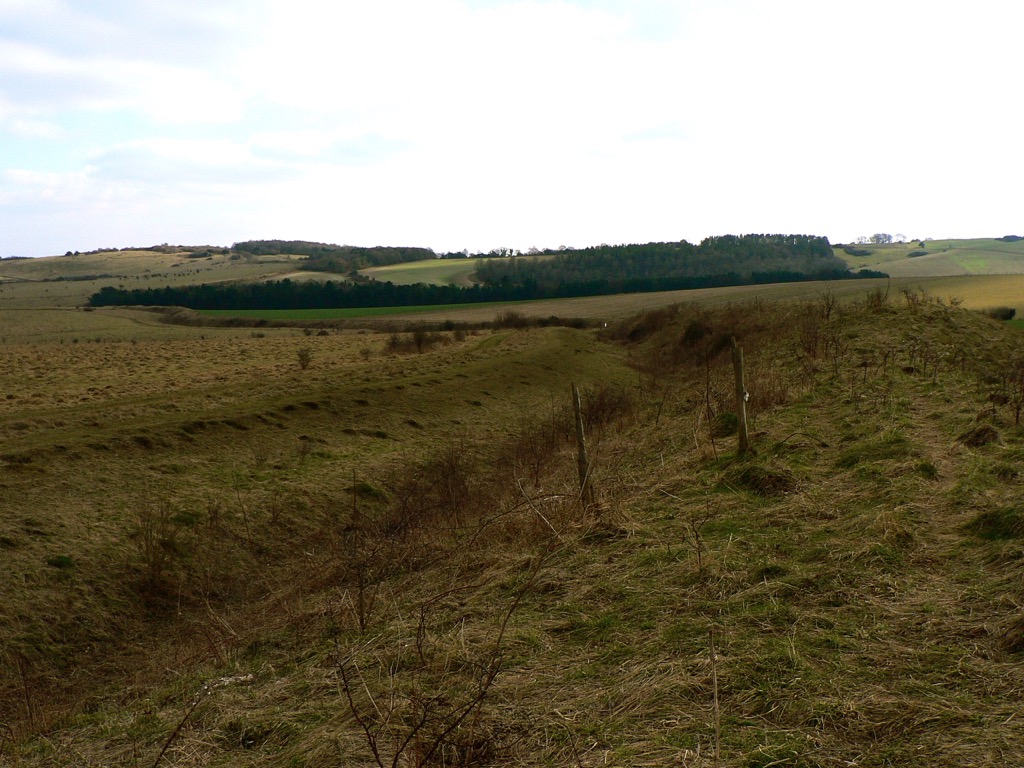
Bokerley Dyke snaking its way southeast. The Saxons would have tried to invade from the left
March may be the official start of spring, a little warmer and with promises to keep, but it also hides a dark secret, for the month has martial connections. Named after Mars, the Roman god of war, it was not only the start of the Roman year, but also the month for mounting military campaigns. Those campaigns, and many more before and since, have left obvious marks on the countryside; battlefields, motte and baileys and castle keeps we would all recognise the names of, from Hadrian’s Wall to the half-mile-long magnificence of Maiden Castle in Dorset, with medieval and Tudor strongholds the length of the country between. The ubiquity of battle and war in every corner of Britain is evidence of the part that conflict has played in our history, but for every famous hillfort, castle and Roman wall, there are dozens of military connections hiding quietly in our countryside.
Among them, the miles of Iron Age Grim’s Dykes or Ditches that are common in Wessex and are believed to be territorial markers. Though not of a sufficient scale for military use – where they can still be tracked on the ground they tend to be of the scale of a modest railway embankment – the ditches have an etymological cousin in Graham’s Dyke, a local name for the Roman’s short-lived Antonine Wall across the Central Lowlands of Scotland. Grim was the Old English name for the Anglo-Saxon god of war, Woden, and other Grim’s Ditches, particularly the one at Colton, east of Leeds, may have been substantial enough to have a defensive use.
Compared to Offa’s Dyke – up to 65 feet at its widest and at least 64 miles long – Grim’s Dykes may seem modest. The eponymous creation of the eighth-century King of Mercia, Offa’s Dyke marks the English-Welsh border (running along Marches of a different kind) and is a potent symbol of tension throughout history. The dyke is built to have commanding views of Powys to the west, with the bank on the Mercian side and the ditch in front to deter any hapless invaders from Wales.
Seven-hundred years before Offa, at Wales’ northwestern horn, advancing Roman legions were confounded by both the treacherous Menai Straits and the Celtic tribes of Ynys Môn (Anglesey) on the other side. Roman Governor Agricola inflicted a punishing and conclusive triumph over them in 78 AD, and Ynys Môn was taken for good, but the memory of his brutal campaign is allegedly preserved in the names of fields; close to Brynsiencyn on the island, one howls its name as Cae-oer-waedd or the ‘Field of Bitter Lamentation’, another is simply “The Field of the Long Battle”.
Comments
Reading the Landscape: Ridges and Bumps
01 02, 13 Filed in: Countryfile | Reading the Landscape
Strip Lynchets at Coombe Hill, Wooton-Under-Edge, Gloucestershire. Photo credit: Synwell / Foter.com / CC BY-NC-ND
As January passes into February, halfway from winter solstice to spring but still the coldest part of the year, it often feels as if it is a distinct season of its own. With low grass in the fields, a touch of frost or a light dusting of snow can reveal a swarm of slumbering lumps, bumps and hummocks of every form, suddenly apparent in a landscape sculpted by the long shadows of the low sun.
Despite appearances, many of these undulations, earthen ripples and waves across the landscape, are not defensive earthworks, ramparts or relics of long-forgotten battles, but evidence of our ancestors’ struggle with the land itself – the remains of various ancient methods of farming – while some are the outcome of nothing more violent than the gradual creep of soil down a hill, occasionally exacerbated by the frolicking trot of sheep.
The most marked features are those shown on Ordnance Survey maps as ‘Strip Lynchets’, the consequence of ploughing along the contours of slopes to create a flat area for crops, as practised in medieval and, occasionally, even earlier times. Dorset and Wiltshire have the best examples – below the Ridgeway near Bishopstone in North Wiltshire and near the village of Loders near Bridport, where giant stair-flights climb the slope; it’s not for nothing that ‘risers’ and ‘treads’ have crept into the terminology of strip lynchets to describe the relevant parts. Further north, at Conistone in Upper Wharfedale and Hall Garth, near Great Musgrave in Cumbria, the effect is gentler, but just as striking.
On more level ground, a pattern of regular undulation can reveal another medieval farming practice – ridge and furrow. Vast open fields were cultivated in furlong (literally furrow-long) strips by tenant subsistence farmers. Working clockwise around their strip, their ploughs turned the sod inward, building up a shallow ridge at the centre of their strip and leaving furrows along the long edges. Hauled by a team of eight oxen, the turning circle in the headland was difficult to achieve without curving slightly to the left at the end of each furlong and a shallow reverse-S or C form to the ridge can often be detected.
In the angular light cast on a February day, far subtler features can be discovered. Thin bands known as terracettes – but sometimes called catsteps or sheep tracks – are formed by soil creeping down steep slopes over the years, a result of repeated saturation and drying. Where bare sedimentary rock is exposed, a light fall of snow might pick out its bedding planes, revealing a succession of sea beds over millions of years or even, on red sandstones, the swash of a desert dune – a geological comfort for the middle of winter.
Reading the Landscape: Snow Business
01 01, 13 Filed in: Countryfile | Reading the Landscape
As the mid-winter celebratory twink and glitter passes by and the season threatens to throw its worst at us in the shape of a cold snap or two, it’s a good time to consider how our landscape has been shaped by ice and snow over our long history. Most of us will be familiar with the U-shaped valleys of the Lake District, Snowdonia and the Scottish Highlands, gouged out by glaciers during the last ice age and hammered into our consciousness by geography lessons since time immemorial, but they are not the only effect of glaciation which, like love, changes everything.
Every part of Britain has been affected in some way by the various glaciations of the last two million years. When glaciers tower to 800 metres, as they did during their most recent appearance between 10 and 20,000 years ago, it should come as no surprise that the features they shape are of a similarly colossal scale, but even a periglacial climate creates huge features in the landscape and their effect upon our countryside is all around us, no matter how far north or south we are.
At 100 metres deep, the Devil’s Dyke, just north of Brighton is the deepest dry valley in the world and its creation was a consequence of what tundra does to porous rock. Situated on chalk, a rock that usually has the porosity of a sponge but which became frozen and impermeable during the last ice age, the area would nevertheless have enjoyed the briefest of Arctic summers. Warm enough, perhaps, to thaw the chalk nearest the surface, which would be sludged away by the meltwater from the snowfields, leaving frozen, impermeable chalk to be eroded by a great meltwater river.
Further north, at the boundary between the ice and tundra, huge mounds called moraines were left at the snouts of glaciers and the most impressive of these forms the Cromer Ridge in North Norfolk, a nine-mile line of hills over 300 foot-high made from clay and boulders bulldozed up from the floor of the North Sea.
But what of the land that was ground down to be eventually deposited as irregular blobs on a landscape hundreds, if not thousands, of miles away? Aside from U-shaped valleys, the most famous outcomes of glacial progress are the whale-back hills known as drumlins. Rounded hills with ‘blunt’ ends that face the origin of the glacier and a long tapered tail on the lee side, drumlins often occur in swarms and form what is termed, rather descriptively, a ‘basket of eggs topography’. There’s an excellent set of them in Ribbleshead in Yorkshire, but since there are 8350 of them in Britain, it might be worth a trudge out in the snow to find your own.
Reading the Landscape: Park Pale
01 12, 12 Filed in: Countryfile | Reading the Landscape
Low embankment, mostly covered in bushes, in Chawton Park Wood. The pale is probably an old royal park boundary and it could run alongside the alignment of a Roman road. Link © Copyright Colin Smith and licensed for reuse under this Creative Commons Licence • http://www.geograph.org.uk/photo/2420145
A familiar label, a ‘park pale’ – as rendered in Old English blackletter on Ordnance Survey maps – marks the ditch and bank that formed the boundary of a medieval deer park. On the ground they might still define an area of woodland pasture, while banks several metres wide, once surmounted by a palisade or, perhaps, still carrying a stone wall, can be substantial even after centuries. The ditch that runs on the inside of the bank is usually less distinct. Their design allowed deer to bound into the park, but prevented them from leaping out again, making the deer park like a huge, terrestrial lobster pot, harvesting meat for the aristocratic table.
It’s a fitting feature to investigate during the season of high octane food, not least because in the low-fat, calorie-counted, gastronomically-tightfisted twenty-first century, Christmas dinner is the closest most of us get to a proper medieval banquet – a seasonal version of which was likely to include venison, while the most kindly of lords might give their servants deer offal – or numbles – for baking into a numble pie.
The model on which the ornamental parks of the eighteenth century were based, the medieval deer park is a landscape tradition whose roots extend back to the Norman conquest. William the Conqueror, who was crowned as an English monarch on Christmas Day, 1066, famously created 36 Royal Forests in the twenty-one years of his reign, reflecting his enthusiasm for the chase. At first, keeping and hunting deer was exclusively the reserve of royalty, but licenses from the King gave members of the aristocracy and senior churchmen the right to hunt on their own lands and a mania for creating deer parks took hold. The remains of one such park – first recorded in 1291, but almost certainly older – can be seen on the eastern side of Lyndhurst in the New Forest, where the pale is 9 metres wide and its bank over a metre high. Another park pale is associated with Kenilworth Castle and Pleasance – Henry V’s manor house in Warwickshire – while the most outstanding example in Scotland is at Fettercairn in Aberdeenshire, where eight miles of pale around the King’s Deer Park may even pre-date the Norman conquest of England.
The frequent occurrence of the park pale on modern maps is a reflection of their ubiquity in medieval landscapes; deer parks covered as much as 2% of England at the start of the fourteenth century and had a political importance to match. While there was no shortage of deer parks, there were shortages of deer because noble huntsmen were rather good at killing their trapped quarry, quicker than they could be re-stocked by hapless deer bounding over the pale. With his large Royal Forests, the King could send deer to his more co-operative and influential lords.
Reading the Landscape: Lych Gate
01 11, 12 Filed in: Countryfile | Reading the Landscape
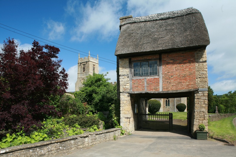
Lych Gate at Long Compton Church, Warwickshire. Photo credit: Hellsgeriatric / Foter.com / CC BY-NC-ND
In a month that starts with All Hallows and All Souls, two opening feast days of November that sift and grade the dearly departed for salvation – first the saints and then the aints – it’s natural to look at the earthly, temporal end of the process. After all, before anybody gets to pray for your soul, there’s the matter of getting into the churchyard in the first place.
Lych gates, which acquired their name from the Saxon word for corpse, stand at the threshold of all thresholds, the entrance to God’s acre. Although many were built before 1549 – Beckenham and Boughton Monchelsea in Kent are dated to the thirteenth and fifteenth centuries, respectively – it became a requirement of the Book of Common Prayer that priests “metyng the corpse at the church style” should commence the service there and that only encouraged construction of lych gates to keep everybody (and every body) dry.
As if hiding their true and gruesome purpose, lych-gates often have a charming gingerbread cottage-cum-chocolate box appeal. They are commonly built from stout timbers and capped by a pleasing and petite doll’s house roof, but the gate at Long Compton church in Warwickshire surpasses all of that to find itself at the peak of picturesque – an entire seventeenth century thatched cottage, minus most of its ground floor, the last surviving of an old row demolished in the 1920s, functions as the churchyard’s gate.
Other designs are grander, the gate at St Peter’s Church, Carmarthen is a vaulted Victorian gothic creation in red sandstone which competes for attention with the lime-rendered tower of Wales’ largest parish church. Sometimes, as at the church of St Germanus, Rame in southeast Cornwall, the gate appears to be a funereal dual carriageway complete with a six-foot long central reservation, the bier or lych stone, to park the deceased on, while benches on either side were provided for the pallbearers, who may have had to walk long distances to church.
Corpse ways to outlying areas of the parish were part of an extensive funereal topography, especially in upland Britain. In Derbyshire, before Coton-in-the-Elms had its own church, bodies were carried a mile and a half along Procession Way to Lullington for burial. The mourners passed under a curve of tree boughs known as the Devil’s Arches on their journey. In Devon, a long-distance footpath – the “Lich Way” – follows a twelve-mile long corpse road over the moor to the church at Lydford and, this being Dartmoor, there are tales of spectral monks walking the trail on moonlit nights.
Toybox: Coining Words
Fashions come and go in children's television. It seems it was only yesterday that we were all learning the names of Iggle Piggle, Upsy Daisy and Makka Pakka, along with their respective character traits of Dead-Eyed Hippy Goon, Little Miss Attention Whore and Victim of a Crippling OCD Affliction. Before them, of course, came countless other bewildering personalities, culminating with the frankly baffling Teletubbies franchise. With matters moving so fast, it is little wonder that parents are occasionally confused, but all of that was before they had to make sense of the world of dismal drivel that is Waybuloo.
Waybuloo is a computer-generated/live action mash-up that features four animated plush toys - the piplings - and a consciously diverse group of children who, for some reason, are known as the cheebies. The piplings live in a magical world called Nara - which looks like an oriental garden halfway up the Brecon Beacons - while the cheebies live somewhere unspecified in the valley, but most probably a village called Fear. It would be hard to find out with any degree of precision as the children generally don't say much, their entire thespian output being confined to jumping up and down on the spot like trainee Big Brother contestants, haring around like a lynch-mob in a Zen garden, shouting 'over there' and lots and lots of pointing. After all the running around, a bit of hide and seek and some more pointing, pipling-directed sessions of 'yogo' break out, yogo being a simplified version of yoga that was, according to the plaff, specially developed for the programme. The children copy the yogo moves of the piplings, the whole aim of which seems to be that the piplings achieve happiness, bliss out and start levitating. This is, apparently, 'buloo' but to anyone with more moral complexity than a paramecium, it will inevitably look like child exploitation.
Just as happiness is 'buloo' and yoga-light is 'yogo', the show always seems ready to coin a new noun, making pointlessly distinctive and, one fears, trademark-able versions of perfectly ordinary words. Butterflies become Narabugs, hide and seek is Peeka and a good idea becomes a Thinkapow. For parents of children who are getting to grips with words still, this kind of nonsense is about as welcome as a pitchfork in the eye.
The stated aim of the show is to 'help the audience learn how to relate to friends and the world around them', clearly a noble intention but, in this case, one framed in terms of New Age piety. Leaving aside the sticky issue of whether or not Waybuloo touts enlightenment through Eastern mysticism - and I can safely leave that aside because it clearly does - the worse thing about buloo is not the casual proselytising of faith, but the utter sanctimony of it all.
In every episode the children are called to yogo by the chimes of a kind of magical crystal clock - a device that should set the alternative spirituality alarm bells clanging like a box of saucepans thrown down the stairs. The adenoidal chanting and upbeat bed of music that drive the programme through its simplistic storylines pauses every now and then for bottle, bamboo and other plinky-plonk percussion. All add to Waybuloo's general air of bright-eyed, insipid twaddle and limited educational worth.
Like a New Age' life coach who guffs and prattles on about holistic approaches while selling you all kinds of mauve and spangly tat, Waybuloo extolls the virtues of happiness and love as if they were something that children don't already have a natural affinity with. Meanwhile, the CG plushes turn out to be merely the avatars of their toy shop incarnations, themselves just an expression of an all-too familiar merchandising machine.
Like In the Night Garden, Teletubbies and countless other franchises, those new toys were in place in short order. It seems that it is not only new words that are being minted in Waybuloo.
to anyone with more moral complexity than a paramecium, it will inevitably look like child exploitation
Waybuloo is a computer-generated/live action mash-up that features four animated plush toys - the piplings - and a consciously diverse group of children who, for some reason, are known as the cheebies. The piplings live in a magical world called Nara - which looks like an oriental garden halfway up the Brecon Beacons - while the cheebies live somewhere unspecified in the valley, but most probably a village called Fear. It would be hard to find out with any degree of precision as the children generally don't say much, their entire thespian output being confined to jumping up and down on the spot like trainee Big Brother contestants, haring around like a lynch-mob in a Zen garden, shouting 'over there' and lots and lots of pointing. After all the running around, a bit of hide and seek and some more pointing, pipling-directed sessions of 'yogo' break out, yogo being a simplified version of yoga that was, according to the plaff, specially developed for the programme. The children copy the yogo moves of the piplings, the whole aim of which seems to be that the piplings achieve happiness, bliss out and start levitating. This is, apparently, 'buloo' but to anyone with more moral complexity than a paramecium, it will inevitably look like child exploitation.
Just as happiness is 'buloo' and yoga-light is 'yogo', the show always seems ready to coin a new noun, making pointlessly distinctive and, one fears, trademark-able versions of perfectly ordinary words. Butterflies become Narabugs, hide and seek is Peeka and a good idea becomes a Thinkapow. For parents of children who are getting to grips with words still, this kind of nonsense is about as welcome as a pitchfork in the eye.
The stated aim of the show is to 'help the audience learn how to relate to friends and the world around them', clearly a noble intention but, in this case, one framed in terms of New Age piety. Leaving aside the sticky issue of whether or not Waybuloo touts enlightenment through Eastern mysticism - and I can safely leave that aside because it clearly does - the worse thing about buloo is not the casual proselytising of faith, but the utter sanctimony of it all.
In every episode the children are called to yogo by the chimes of a kind of magical crystal clock - a device that should set the alternative spirituality alarm bells clanging like a box of saucepans thrown down the stairs. The adenoidal chanting and upbeat bed of music that drive the programme through its simplistic storylines pauses every now and then for bottle, bamboo and other plinky-plonk percussion. All add to Waybuloo's general air of bright-eyed, insipid twaddle and limited educational worth.
Like a New Age' life coach who guffs and prattles on about holistic approaches while selling you all kinds of mauve and spangly tat, Waybuloo extolls the virtues of happiness and love as if they were something that children don't already have a natural affinity with. Meanwhile, the CG plushes turn out to be merely the avatars of their toy shop incarnations, themselves just an expression of an all-too familiar merchandising machine.
Like In the Night Garden, Teletubbies and countless other franchises, those new toys were in place in short order. It seems that it is not only new words that are being minted in Waybuloo.
Two birds and a bag full of stones
02 11, 09 Filed in: Strange Days | Articles
It had been a long walk through the Shropshire hills in search of fossils and, with a good morning’s work completed and a bag full of rocks, I came down through the contours to Ludlow in search of a pub lunch.
Checking the map, I noticed a path beside an interesting looking woodland stream that was only slightly out of the way between fossils and lunch. To fill the miles I decided to do a spot of birdwatching on my way down and was looking forward to a light hike along it in search of Cinclus cinclus - the Dipper - a small brown bird that looks somewhat like a stunted, barrel-chested Blackbird with a white bib. Dippers are tenacious birds that often perch on rocks in the middle of fast-flowing shallow streams with their tails cocked like oversized Wrens. They feed by diving and swimming - even walking - underwater to catch aquatic invertebrates; at least, that’s what I’ve surmised from the bird books because, in all my years of watching, I’ve never actually seen one.
His one-man mission to spot our feathered friends, identify and then loathe them deeply seemed to be going well.
Despite what the field guides may tell you, the most common appearance of a Dipper is as a line drawing on a ‘context board’ erected by the river’s edge - those mounted information panels that feature paintings of bucolic loveliness, of habitats teeming with biodiversity, the preferred modern term for ‘life’. The boards are usually installed after a programme of works to dredge the last few shopping trolleys out of a river and present an optimistic vision of a habitat created by a partnership of organisations - organisations with striking logos designed to fit along the bottom of a context board. This particular panel was illustrated with an artist’s impression of what it would look like if all the interesting organisms from thirty miles around were condensed into a 300 yard stretch of river. I’ve long realised that anywhere that you can hear the white noise rush of a weir you’ll see a Dipper on a nearby context board and absolutely none in the river.
Moving on from the board, I scanned the river itself to no avail and decided to walk along the river a while. It wasn’t long before I saw someone else along the path, binoculars to his eyes, apparently studying a Mallard on the bank. I was a long way from home and looking for something specific, so what better than a local birdwatcher happy to share his insight into the birds on his patch? I made my way over and asked him if he knew of any Dippers on the river. It wasn’t long before I realised that I was talking to someone I now regard to be not only the world’s most unsuccessful birdwatcher, but - on account of his slightly swivel-eyed comportment - possibly its most drunken one as well.
He was almost completely unintelligible, except for the occasional ornithological English noun forming the victorious crescendo of an otherwise unfathomable sentence, its precise meaning slurred away like mud off a boot.
“Hrrurr gretsch pfftdf, Wagtail, mrmpgghaw (cough) azzerbunmhher, Swan”, was the rough gist of his part of the conversation which, at one point, inexplicably veered into “hhrghnngh wozzun hang glider” as he pointed at a passing microlight in the sky.
Joining the Dipper, between achingly rare orchids and damsel flies, a Heron and Mute Swan on the context board was the ubiquitous Mallard, a species that my new friend was keen to tell me his opinion of. After about five minutes wishing I was anywhere else but there, my ears had at last started to become accustomed to the drawl of drunken expletives and general ill-will towards the world in general and winged creatures in particular: “Them ducks, frawghhhar, gnmmph vicious bastards, you harrrrunt to look out for them.”
It had started to rain by this point, but the inebriated aviphobe was in full bird hating mode; it turned out that he recoiled from blackbirds, swallows and wagtails also - their specific crimes were not spoken of, but he despised them all the same. His one-man mission to spot our feathered friends, identify and then loathe them deeply seemed to be going well. He was just raising ire at pigeons and pouring scorn on crows when he paused for a moment and asked, “You RSPB, then?” Surprised and, indeed, in fear of being branded a collaborator, I assured him that I wasn’t. Mellowing a little he explained that he hadn’t seen a Dipper for years, which is probably just as well for the Dipper.
I pulled myself away, leaving him on the river bank, wandering away as nonchalantly as I could - at one point, I had fantasized about throwing some of my fossils at him and legging it down the path. The last I saw of him, he was chasing a duck.